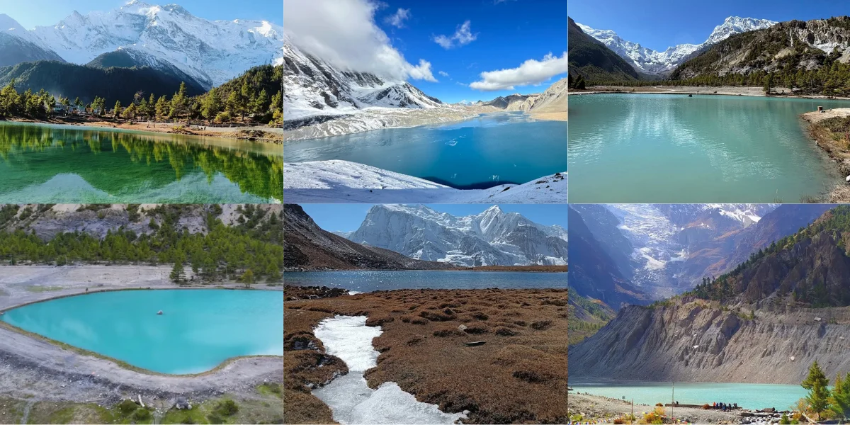
High in the Annapurna region, Manang is home to some of Nepal’s most stunning glacial lakes. From the world-famous Tilicho Lake to hidden gems like Moon Lake and Dona Lake, each one is surrounded by towering Himalayan peaks and untouched natural beauty.
These Manang lakes are more than just water; they are experiences. Crystal-clear reflections, turquoise waters, alpine meadows, and serene silence make every visit unforgettable.
Whether you’re trekking, exploring, or simply soaking in the views, the lakes of Manang promise adventure, peace, and pure magic.
Let’s explore the best lakes in Manang, their colors, features, and how to reach them, so you can plan your own journey.
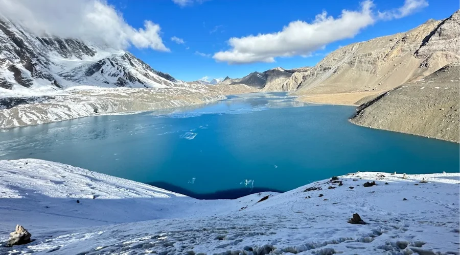
1. Tilicho Lake
Tilicho Lake Altitude: 4,919 meters (16,138 feet)
Location: Khangsar Village, Manang District, Gandaki Province, Nepal
Local Name: Tilicho Tal
Tilicho Lake Coordinates: 28.682° N, 83.850° E
Color: Turquoise blue, sometimes partially frozen in winter
Tilicho Lake is one of the highest lakes in the world, located in the Annapurna Himalayas. It’s fed by glacial meltwater from Tilicho Peak (7,134 m).
Jagged snow-capped peaks, moraine cliffs, and high alpine meadows surround the lake. Tilicho Lake’s stunning turquoise color in summer makes it a photographer’s paradise.
Tilicho Lake Features and Attractions:
- Sacred for Hindu pilgrims; legend says it is mentioned in the Ramayana as a lake where Bali prayed.
- Glacier-fed with crystal-clear icy water, sometimes partially frozen in spring and fully frozen in winter.
- Surrounded by Tilicho Peak, Nilgiri Himal, and Khangsar Kang, offering a panoramic view of the Annapurna range.
- Located in a remote and pristine environment, making it ideal for solitude and adventure seekers.
- You may see Himalayan marmots, snowcocks, and sometimes blue sheep in the surrounding hills.
How to reach Tilicho Lake?
- Most trekkers access Tilicho Lake via the Annapurna Circuit Trek.
- From Manang village (3,519 m / 11,545 ft): trek to Khangsar village (3,734 m / 12,254 ft) → Tilicho Base Camp (4,150 m / 13,615 ft) → Tilicho Lake (4,919 m / 16,138 ft).
- Manang to Tilicho Lake Distance: 19 km (12 miles) from Manang; generally, takes 2 days due to altitude and acclimatization needs.
- Trek Difficulty: Moderate to strenuous; high altitude can cause Acute Mountain Sickness (AMS), so proper acclimatization is required.
- Best Season: Spring (March–May) for blooming flowers, Autumn (September–November) for clear skies and vibrant colors.
Tips for Tilicho Lake Trek:
- Start early from Khangsar for the best sunlight on the lake.
- Carry warm clothing, as temperatures can drop below -10°C (14°F) even in summer.
- Stay hydrated and acclimatize properly to avoid altitude sickness.
- Camping at the base is popular; lodges are limited and basic.
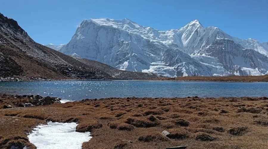
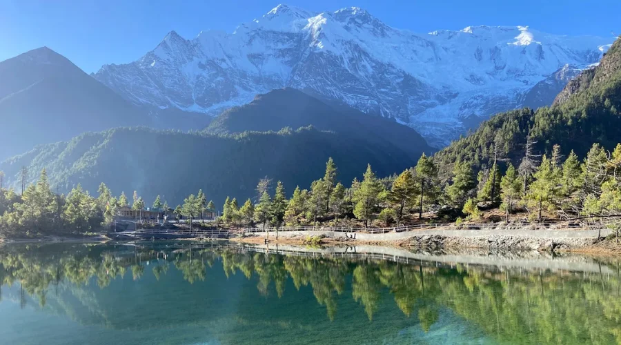
2. Gangapurna Lake
Gangapurna Lake Altitude: 3,540 meters (11,614 feet)
Lake Location: Below Manang Village, Gandaki Province, Nepal
Local Name: Gangapurna Tal
Coordinates: 28.667° N, 83.983° E
Color: Greenish-turquoise, reflective of glacier meltwater
Gangapurna Lake is a serene glacial lake near Manang village, formed by meltwater from the Gangapurna Glacier and snowmelt from Annapurna III. Unlike Tilicho, it’s easily accessible and serves as a beautiful spot for acclimatization hikes.

Gangapurna Lake Features and Attractions:
- Mirrors the surrounding peaks, offering perfect photography conditions.
- Less crowded, ideal for travelers seeking tranquility.
- Flora and Fauna: Alpine shrubs, Himalayan poppies, and grazing yaks; occasionally snowcocks and blue sheep.
- Cultural Aspect: Locals consider it sacred, and you might see small prayer flags around its edges.
- Climate: Temperatures can drop to -5°C (23°F) at night, but it’s milder than higher lakes like Tilicho.
How to reach Gangapurna Lake?
- You can reach Gangapurna Lake in just a 10–15-minute downhill walk from Manang village (3,519 m / 11,545 ft).
- Starting Point: Most trekkers visit Gangapurna Lake as a rest day excursion from Manang.
- Manang to Gangapurna Lake Distance: About 2 km from the Manang village center.
- Trek Difficulty: Easy to moderate, suitable for almost all trekkers.
- Best Season: Spring (March–May) for lush greenery and flowers; Autumn (September–November) for crystal-clear reflections.
Tips for Gangapurna Lake:
- Morning is the best time for photography; the lake is calm, reflecting the mountains.
- Carry snacks and water; there are no lodges directly beside the lake.
- A short extension to the Ice Lake trail can be done from here for adventurous trekkers.
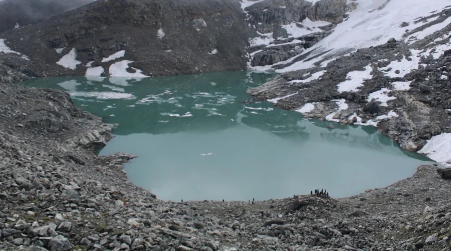
3. Ice Lake (Kicho Tal)
Ice Lake Altitude: 4,620 meters (15,157 feet)
Location: Upper Manang, Gandaki Province, Nepal
Local Name: Kicho Tal
Ice Lake Coordinates: 28.673° N, 84.011° E
Color: Turquoise to emerald, changes with sunlight and glacier melt
Ice Lake, locally called Kicho Tal, is a high-altitude alpine lake near Upper Manang. It is famous for its vivid turquoise water and the panoramic backdrop of the Annapurna range. The lake remains frozen for much of the winter, but in spring and autumn, it’s a stunning spot for photography.
Ice Lake Features and Attractions:
- Surrounded by snow-capped peaks, alpine meadows, and small glaciers.
- Offers stunning reflection views of the surrounding mountains in calm weather.
- The area is less crowded than Tilicho Lake, offering solitude and tranquility.
- Popular for acclimatization hikes by trekkers on the Annapurna Circuit.
- Flora includes alpine flowers, dwarf shrubs, and moss; wildlife sightings may include Himalayan snowcock and marmots.
How to reach Ice Lake?
- Starting from Upper Manang village (3,540 m / 11,614 ft), it’s about a 3–4 hour roundtrip hike.
- Manang to Ice Lake Distance: Approximately 6 km (3.7 miles) from the village.
- Trek Difficulty: Moderate, with some rocky trails and gradual ascent.
- Best Season: Spring (March–May) for blooming flowers; Autumn (September–November) for clear skies.
Tips for Ice Lake:
- Morning treks offer the best calm reflections and photo opportunities.
- Carry warm clothing; high-altitude winds can make it feel colder than Tilicho Lake.
- No lodges nearby; trekkers usually return to Upper Manang village for meals and stay.
4. Kajin Sara Lake
Kajin Sara Lake Altitude: 5,020 meters (16,469 feet)
Location: Upper Manang, near the border of Nar and Manang valleys, Gandaki Province, Nepal
Local Name: Kajin Sara Tal
Coordinates: 28.746° N, 84.025° E
Color: Crystal clear with turquoise to light blue hues
Kajin Sara Lake is a recently discovered glacial lake, often claimed to be one of the highest in the world, surpassing Tilicho Lake in elevation. It lies in a remote area near Upper Manang and the Nar Phu Valley.
Its discovery in recent years has attracted mountaineers and adventurous trekkers seeking new high-altitude experiences.
Kajin Sara Lake Features and Attractions:
- Surrounded by pristine glaciers and towering peaks of the Annapurna region.
- Remote and virtually untouched, offering a peaceful trekking experience.
- Clear glacial water with an intense turquoise-blue color.
- Difficult terrain, suitable for experienced trekkers and mountaineers.
- Wildlife: Rare sightings of snow leopards and Himalayan blue sheep have been reported.
How to reach Kajin Sara Lake?
- Accessible via Upper Manang village or the Nar Phu Valley route.
- Manang to Kajin Sara Distance: Approximately 10–12 km (6–7 miles) from Upper Manang, requiring a 6–8 hour trek depending on acclimatization.
- Trek Difficulty: Strenuous to challenging due to high altitude, rocky trails, and glacial terrain.
- Best Season: Autumn (September–November) for clear skies; spring is also suitable but may have some snow on the trail.
Tips for Kajin Sara Lake:
- Acclimatization is crucial; stay in Manang or Khangsar for at least 2–3 days before attempting.
- Trekking here requires experience in high-altitude trekking and proper gear (crampons, trekking poles).
- No lodges nearby; camping is necessary with proper supplies.
- Early morning provides the best light for photography, reflecting the surrounding mountains in the lake.
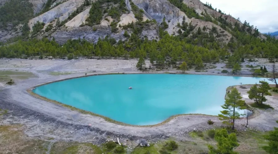
5. Ponkar Lake
Ponkar Lake Altitude: 4,100 meters (13,451 feet)
Location: Near Bhimthang, Manang District, Gandaki Province, Nepal
Local Name: Ponkar Tal
Coordinates: 28.641° N, 84.013° E
Color: Crystal clear blue, often reflecting surrounding peaks
Ponkar Lake is a lesser-known glacial lake located near Bhimthang, along the Manaslu-Manang trekking region. It is fed by meltwater from the nearby Ponkar and Kechakyu glaciers.
The lake is surrounded by snow-covered peaks, alpine meadows, and rugged terrain, offering a peaceful and pristine environment for trekkers.
Ponkar Lake Features and Attractions:
- Stunning reflection of the surrounding mountains on calm days.
- Remote and less crowded, perfect for solitude seekers.
- Nearby wildlife includes Himalayan marmots, snowcocks, and occasionally blue sheep.
- The area is rich in alpine flora, including small shrubs, wildflowers, and moss-covered rocks.
- Ideal for trekkers looking for off-the-beaten-path Himalayan experiences.
How to reach Ponkar Lake?
- Ponkar Lake is accessed via the Bhimthang village trail, often included in Manaslu Circuit extensions.
- Bimthang to Ponkar Lake Distance: 4–5 km (2.5–3 miles) from Bhimthang village, approximately 2–3 hours of hiking.
- Trek Difficulty: Moderate, with some rocky and uneven terrain.
- Best Season: Spring (March–May) for greenery, Autumn (September–November) for clear skies.
Tips for Ponkar Lake:
- Carry sufficient water and snacks; no lodges are nearby.
- Early morning or late afternoon is best for photography due to soft lighting.
- The lake is accessible for a day trip from Bhimthang, making it a good detour while trekking.
6. Green Lake
Green Lake Altitude: 3,850 meters (12,631 feet)
Location: Upper Pisang, Manang District, Gandaki Province, Nepal
Local Name: Green Tal
Coordinates: 28.613° N, 83.965° E
Color: Emerald green, varying with sunlight and glacier runoff
Green Lake, Manang is a small, tranquil alpine lake near Upper Pisang village. It’s less famous than Tilicho or Ice Lake but is admired for its serene emerald water and scenic surroundings. The lake is surrounded by alpine meadows, snow-capped peaks, and rocky cliffs.
Green Lake Features and Attractions:
- Emerald-colored water that changes hues throughout the day.
- Surrounded by alpine flora and grazing yaks, creating a picturesque Himalayan setting.
- Peaceful, quiet location, ideal for resting and acclimatization hikes.
- Offers photography opportunities with reflections of Annapurna peaks in calm water.
- Nearby villagers consider it a sacred water source.
How to reach Green Lake?
- Start from Upper Pisang village (3,300 m / 10,827 ft) and hike 1–2 hours to reach the lake.
- Pisang to Green Lake Distance: Approximately 3 km (1.9 miles) from the village.
- Trek Difficulty: Easy to moderate, suitable for most trekkers.
- Best Season: Spring (March–May) for greenery and flowers; Autumn (September–November) for clear reflections.
Tips for Green Lake:
- Morning is the best time for photography; the lake reflects surrounding peaks beautifully.
- No lodges nearby; trekkers can return to Upper Pisang village.
- Ideal for a half-day excursion, making it suitable for casual trekkers or rest days.
7. Blue Lake (Chindi Lake)
Blue Lake Altitude: 4,150 meters (13,615 feet)
Location: Near Upper Manang, Gandaki Province, Nepal
Local Name: Chindi Tal
Coordinates: 28.675° N, 84.005° E
Color: Deep blue, almost sapphire, reflecting the sky and surrounding peaks
Blue Lake, locally known as Chindi Tal, is a peaceful high-altitude lake near Upper Manang. Its calm water, turquoise-blue color, and quiet surroundings make it a hidden gem for trekkers.
The lake is spring fed, maintaining its deep blue hue year-round, and is surrounded by rocky cliffs and alpine meadows.
Blue Lake Features and Attractions:
- Turquoise-blue water, calm and reflective.
- Surrounded by alpine flowers, grazing yaks, and small shrubs.
- Less crowded, offering tranquil, off-the-beaten-path trekking experience.
- Excellent for photography and nature observation.
How to reach Blue Lake Manang?
- Start from Upper Manang village (3,540 m / 11,614 ft) and hike for about 1.5–2 hours to reach Blue Lake.
- Manang to Blue Lake Distance: 5 km (3 miles) roundtrip.
- Trek Difficulty: Moderate, with a slight uphill climb over rocky terrain.
- Best Season: Spring and Autumn for clear skies and vibrant lake color.
Tips for Blue Lake:
- Carry water and snacks; no lodges nearby.
- Morning is best for reflections and photography.
- Can be combined with Ice Lake for a half-day trekking extension.
8. Dona Lake (Dona Tal)
Dona Lake Altitude: 4,200 meters (13,780 feet)
Location: Nasong Rural Municipality, Manang District, Gandaki Province, Nepal
Local Name: Dona Tal
Coordinates: 28.489° N, 84.486° E
Color: Crystal-clear blue green
Dona Lake is a C-shaped glacial lake in Nasong Rural Municipality. The lake has cultural and religious significance for the local communities, who believe it brings good fortune. Its location amidst glaciers and alpine pastures makes it a remote and peaceful trekking spot.
Dona Lake Features and Attractions:
- Unique C-shaped form, rarely seen in Himalayan lakes.
- Surrounded by snow-capped peaks, moraine cliffs, and alpine meadows.
- Sacred for locals; small prayer flags are often found around the lake.
- Offers a tranquil environment for meditation, photography, and nature walks.
How to reach Dona Lake?
- Accessed via trekking from Nasong village.
- Distance: 6–7 km (3.7–4.3 miles), roughly 3–4 hours trek one way.
- Trek Difficulty: Moderate, with some uneven paths and rocky sections.
- Best Season: Spring and Autumn for clear skies and vibrant surroundings.
Tips for Dona Lake:
- Carry warm clothing; winds can be strong at high altitude.
- Respect local customs; avoid disturbing prayer flags or performing rituals without permission.
- Camping may be necessary for overnight stay due to its remote location.
9. Moon Lake
Moon Lake Altitude: 4,350 meters (14,271 feet)
Location: Near Khangsar Village, Manang District, Gandaki Province, Nepal
Local Name: Moon Tal
Coordinates: 28.700° N, 84.020° E
Color: Light turquoise to deep blue depending on sunlight
Moon Lake is a small and secluded alpine lake near Khangsar. It is a hidden gem that is less visited by trekkers, offering serenity and untouched natural beauty.
Surrounded by rocky cliffs and snow-covered peaks, it is ideal for those who love solitude and high-altitude trekking.
Moon Lake Features and Attractions:
- Calm, turquoise water with pristine surroundings.
- Surrounded by snow, glaciers, and alpine meadows.
- Less popular, providing a peaceful escape from main trekking routes.
- Perfect for photography, camping, and reflection in nature.
How to reach Moon Lake?
- Accessible from Khangsar Village (3,734 m / 12,254 ft).
- Khangsar to Moon Lake Distance: 4 km (2.5 miles), about 2 hours one-way trek.
- Trek Difficulty: Moderate, with some steep and rocky trails.
- Best Season: Spring and Autumn for clear weather and vibrant lake colors.
Tips for Moon Lake:
- Early morning light is best for capturing reflections.
- Carry water, snacks, and warm clothing; there are no lodges nearby.
- Ideal for day hikes or overnight camping for adventure travelers.